Blogs

Dynamic UKC overlays on Trelleborg SafePilot PPUs

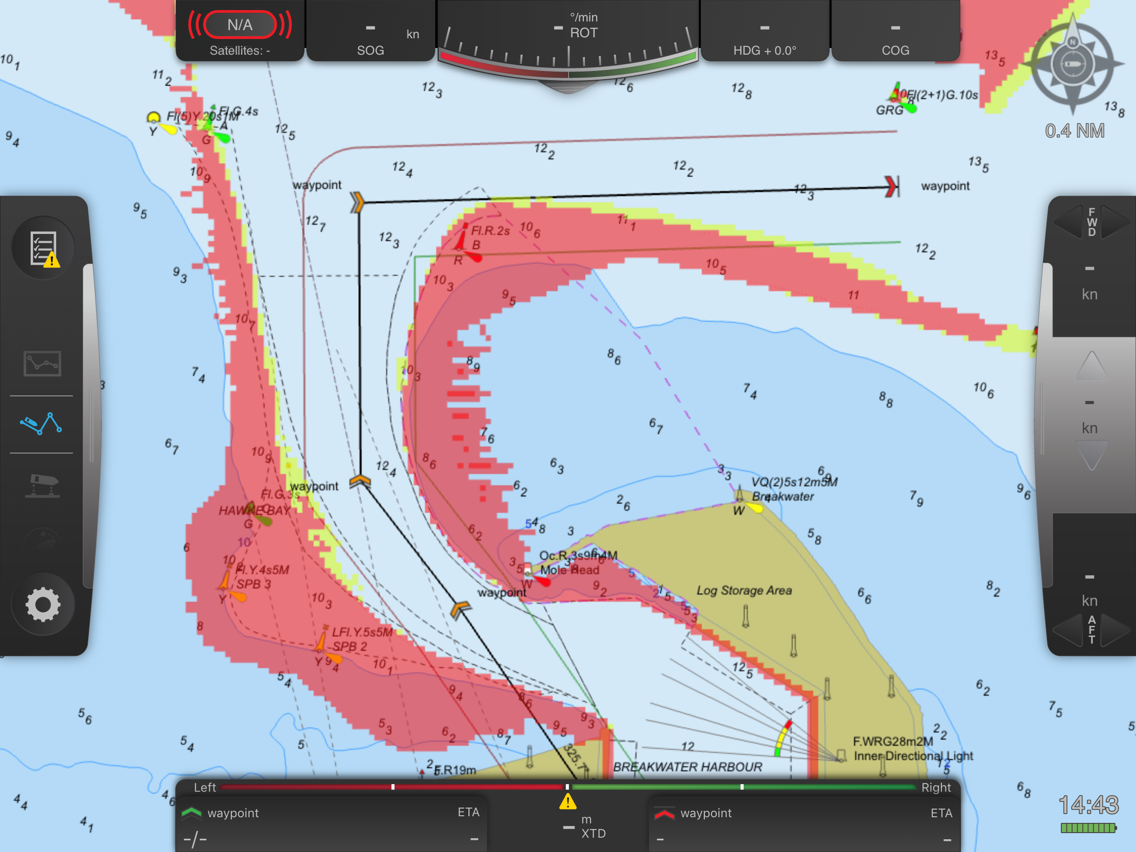
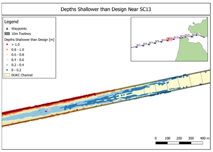
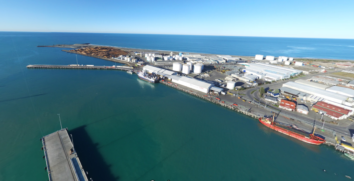
A recent collaboration with Trelleborg means that is now possible to view dynamic under keel clearance information in real time within Trelleborg SafePilot. The overlay highlights areas that are unsafe for a ship to navigate through. The overlay differs from traditional go/no-go displays with Electronic Chart Systems (ECSs) because it not only conveys whether it is safe to transit a particular area now, but it also predicts, before the transit, whether it will be safe when a ship reaches a particular area.

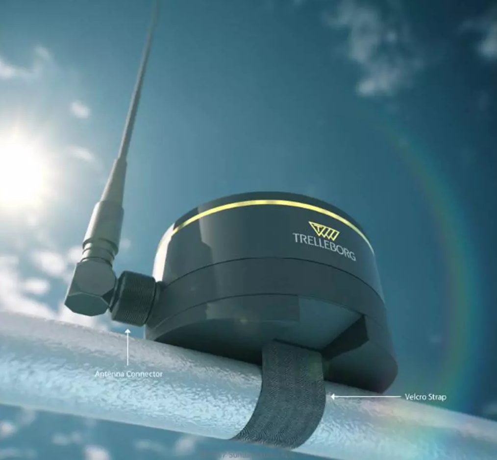
The overlay complements Trelleborg’s CAT MAX PPU solution, which includes a built-in 3-axis (6-DOF) motion sensor that can be used for real-time UKC. This sensor offers precise and independent rate of turn, roll, and pitch, allowing for accurate predictions when doing turns and navigating in confined waters.

Dynamic Under Keel Clearance information overlayed onto Trelleborg’s CAT MAX PPU.
Blogs

New weather displays at the Victorian Ports Corporation in Melbourne

Victorian Ports Corporation (Melbourne) (VPCM) is the Victorian Government organisation that operates the Vessel Traffic Service (VTS) in Melbourne. In 2019 VPCM commissioned OMC to upgrade their VTS environmental data displays. The upgrade used the PortWeather platform. 

Customised dashboards were created for VTS operators, marine pilots, and engineers, enabling optimised viewing of the port’s 60+ metocean instruments. The flexibility of internet browser viewing has enabled easy access to other parties such as exempt ship masters and dredging contractors. Display formats included large VTS screens, mobiles and portable pilot units (PPUs). Alerting and data downloading capabilities were also provided, enabling configurable management of various aspects of the data for different stakeholders. 

In addition to the display of real-time observations, PortWeather can also display weather forecasts and calculated virtual sources in the middle of channels. When available, it can display raw water levels or winds. This enables OMC to manage as much of the upstream data as possible, which leads to better data availability and quality control. As a vested end user, OMC uses this data for operational products like DUKC® and BerthAlert. 

The dashboard below is configured for a permanent pilot station monitor, displaying all the most recent, relevant metocean parameters and their availability.

PortWeather displays.

The dashboard below provides engineers with numerous options to view, interrogate and download wave data at selectable timescales. 

PortWeather wave displays.

The next dashboard is configured for mobile phones. It includes the display of calculated tides and currents mid-channel at Rip Bank in Port Phillip Heads. 

PortWeather layout for mobile devices.

The dashboard below displays wind roses and history plots from gauges along the length of the bay and the channels. 

PortWeather wind displays.

“My involvement with the PortWeather data presentation website began at the first stage – what do we as pilots want to see and how do we want to see it. The end product is a fantastic aid to decision making and planning of passages where wind, weather, tidal height and currents play a role – in Melbourne and Geelong that is every piloted ship! Two aspects are of particular use – knowing we share the exact same data as the VTS and the mobile phone optimised site(s), as this aids in job planning without having our PPU’s open and running. Finally there have been requested changes over time, and these were actioned promptly and to our satisfaction.”

Capt Toby Shelton, Port Phillip Sea Pilots  

Blogs

Understanding vessel motions at Belfast

OMC has undertaken a set of surveys at Belfast Harbour (Northern Ireland) to understand how vessels squat during port approaches and departures. While primarily aimed at deep draft vessels, the surveys were unique, as they included the Stena Line Ro-Ro and two cruise vessels, a first for OMC.

The surveys quantified the actual squat incurred (the dynamic increase of draft) and will assist the port to meet its obligations under the Port Marine Safety Code. The port is using the results to update its procedures to ensure all vessels maintain a safe clearance. These surveys will also assist in the future development of trade through optimised channel usage and design.

These full-scale vessel movement surveys (FSVMA) represent a core service that OMC provides to port authorities and regulators across the globe. To date, we have surveyed over 650 vessels worldwide.

Blogs

Minimising dredging costs at Weipa

The Port of Weipa is situated on the eastern shore of the Gulf of Carpentaria in far North Queensland. Weipa is Australia’s largest bauxite port, exporting approximately 30 million tonnes per annum on post-Panamax vessels under DUKC® advice since 2008.

OMC works closely with both Rio Tinto and North Queensland Bulk Ports Corporation (NQBP) to facilitate efficient operations at the Port of Weipa. OMC has a long history working with NQBP stemming back to Hay Point, where the first DUKC® was installed in 1993.

The port itself is located at Lorim Point at the end of a 25 km dredged channel. The long channel is needed to find deep water as the bathymetry around Weipa is relatively flat. Being located at 12 degrees S latitude, Weipa is frequently subjected to the cyclones that develop in the Coral Sea and in the Arafura Sea each Australian summer, and to the annual monsoon conditions that occur every autumn.

These annual weather events have a significant impact on Weipa’s operations. After cyclones occur, DUKC® depths need to be quickly updated with post-cyclone survey data to ensure the DUKC® units reflect the post-cyclone conditions. An annual dredging campaign occurs at the end of the monsoon season, where the sediment that has accumulated over the past year is dredged, thereby preparing the channel for the next year. OMC assists the Port of Weipa in preparing for the annual dredging by analysing the survey data, identifying dredging locations, calculating sedimentation rates, and advising on dredge depth targets to allow Weipa to maintain target drafts throughout the year.

2019 was a particularly intense year for the Port of Weipa because the monsoon was much stronger than normal, and the port was subject to three cyclones, all of which induced significantly more sediment in the channel than usual. Additional work was required to assess if the dredge would be able to clear the channel within its scheduled timeframe. The dredging campaign was finally competed in July 2019 and the port returned to regular operations.

Blogs

OMC Principal Engineer Laurence Benn joins the Board of PIANC ANZ

PIANC is the leading global forum for experts in the waterborne transport industry to gather and exchange ideas. OMC has been an active participant in PIANC and its activities for many years, including the development of Harbour Approach Channels – Design Guidelines (2014).

Laurence is an active member of PIANC, and he is also the Young Professional representative for the recently established Victoria/Tasmania Chapter. He is excited to help continue promoting the work of PIANC ANZ in his new role on the Board.

Blogs

Timaru berth design

PrimePort Timaru are investigating the feasibility of constructing a new berth in Evans Bay, outside the relative shelter of the inner harbour (see map link). As the proposed berth will be more exposed to waves and long-wave surge than the existing berths at the port, PrimePort engaged MetOcean Solutions and OMC International to perform an integrated berth design and downtime study.

To perform the study, MetOcean Solutions used state-of-the-art phase-resolving wave modelling to generate a database of a 10-year hindcast of swell and infragravity long-wave conditions at the proposed berth location, while OMC used in-house mooring software and experience in moored vessel motion analysis. Together, the two companies delivered to PrimePort an estimate of the expected downtime for a range of vessels, including bulk carriers and cruise vessels. At the request of PrimePort, OMC also provided recommendations around wharf length and fendering capacity.
Timaru
Timaru2
1 2 3 4 5 6 7